British Forces
Campomarino's WWII airfields
Istituto Geografico Militare
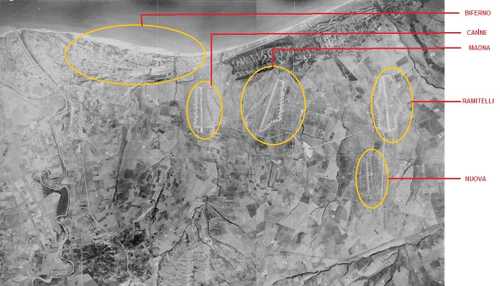
This is an aerial photograph of the Campomarino plain dated 9 Sep. 1945 (© 2008 Istituto Geografico Militare). It was taken from an altitude of 7500m at a scale of 1:55000. The area depicted here is East of the town of Termoli (Molise region, province of Campobasso) and is comprised between the river Biferno to the West and the river Saccione to the East both visible on the right and left side of the photograph.. The airfields coordinates were: BIFERNO airfield runway & dispersal: 41°57'34.95"N, 15°2'55.67"E; CANNE airfield runway & dispersal: 41°55'50.77"N, 15°3'45.91"E; MADNA airfield runway & dispersal: 41°55'10.99"N, 15°4'46.76"E; RAMITELLI airfield runway & dispersal: 41°53'53.25"N, 15° 6'48.17"E; NUOVA Airfield 41°53'3.02"N, 15°4'57.12"E
3469 Views
12/2/2014